The fourth step is proposing measures in the neighbourhood to create quieter, safer streets with no direct through-routes for motor vehicles.

The fourth step is proposing measures in the neighbourhood so that:
- there is no direct through route for motorised vehicles
- all homes can be accessed by private vehicles
- new public space is created, activating the streets.
The main tools available include:
- Modal filters: A simple bollard or planter through which people can travel by walking or cycling, but not by car.
- Pocket parks: These are two sets of filters, spaced slightly apart to create a new area through which people can only travel by walking or cycling (see Figures 3d or 3e).
- Diagonal filters: Bollards or planters diagonally through a cross-roads. These minimise the need for reversing, facilitating refuse collection or other large vehicle movements.
- Bus gate: A modal filter, through which buses can travel. This is usually camera-enforced, and its operation can be timed.
- Banned turns (including point no entry or point no exit): Removing the possibility of motorised vehicles to perform certain turns.
- One-way streets: These can be effective in combination with banned turns or when introducing conflicting one-ways but can lead to increased speeding.
The location of these interventions can be determined and refined in partnership with local community groups at co-design events.

Figure 3d: Pocket park on Whitney Road, Waltham Forest (Image: London Borough of Waltham Forest)
Figure 3e: New space created by a four-way modal filter in De Beauvoir, Hackney (Image: Action Vision Zero)
To determine the location of modal filters and traffic restrictions, start at any boundary road and travel through the neighbourhood, trying to reach another boundary road.
There will be two main movements:
- parallel to a boundary road (which will often be congested, have traffic lights and pedestrian crossings)
- corner cutting (to avoid a signalised junction or roundabout).
In both cases, the proposals will have to prevent motor vehicles from travelling through.
In practice, this will mean vehicles will have to leave the neighbourhood via the same boundary road they entered from.
Figure 3e shows a worked exercise to determine the location of filters. The order of the steps is indicative only.
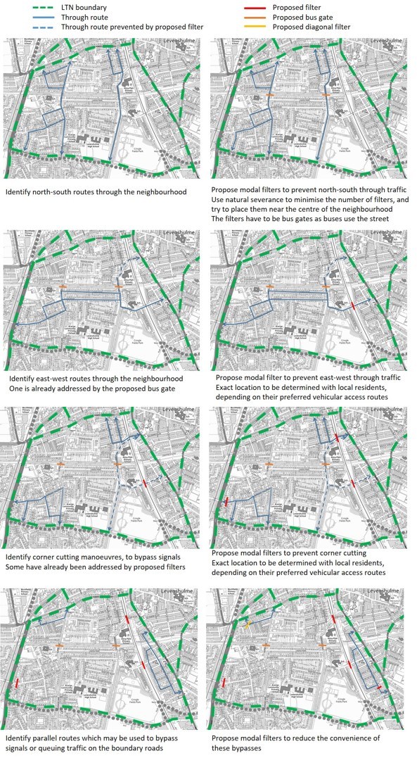
Figure 3e: Placing the filters.
For the best outcome, we recommend the following.
- Minimise the cost of the scheme by minimising the number of filters: this can usually be achieved by locating filters along severance lines such as railway lines and parks.
- To minimise inconvenience to car journeys which start or end in the cell, place filters towards the centre of the neighbourhood, ensuring residents can drive to their closest boundary road. However, if the LTN is bounded by a local high street or major cycling corridor, it might be preferable to locate filters closer to this boundary, reducing the danger from turning movements.
- Diagonal filters can be used to create loops which minimise the need for three-point turns or reversing, especially by larger vehicles.
- Modal filters should be located where they can create the most community value. Wherever possible, single filters should be upgraded to pocket parks, particularly next to schools, community centres or other areas of high footfall.
Any proposal must, of course, retain vehicle access to any property, including for emergency services, who are statutory consultees.
All modal filters should contain lockable bollards to allow emergency services through.
The proposals might also have to remove any existing width restrictions which may otherwise prevent access for larger vehicles.
Finally, consideration must be given to the junctions at the corners of an LTN.
In some cases, it may be necessary to reintroduce banned turns which may otherwise result in extremely long detours for car journeys. Or in dangerous u-turns and three-point turns on residential streets just outside the LTN.
Figure 3f shows the proposals for the low-traffic neighbourhood developed in Figure 3e, clearly highlighting the access routes for motorised vehicles from each boundary road.
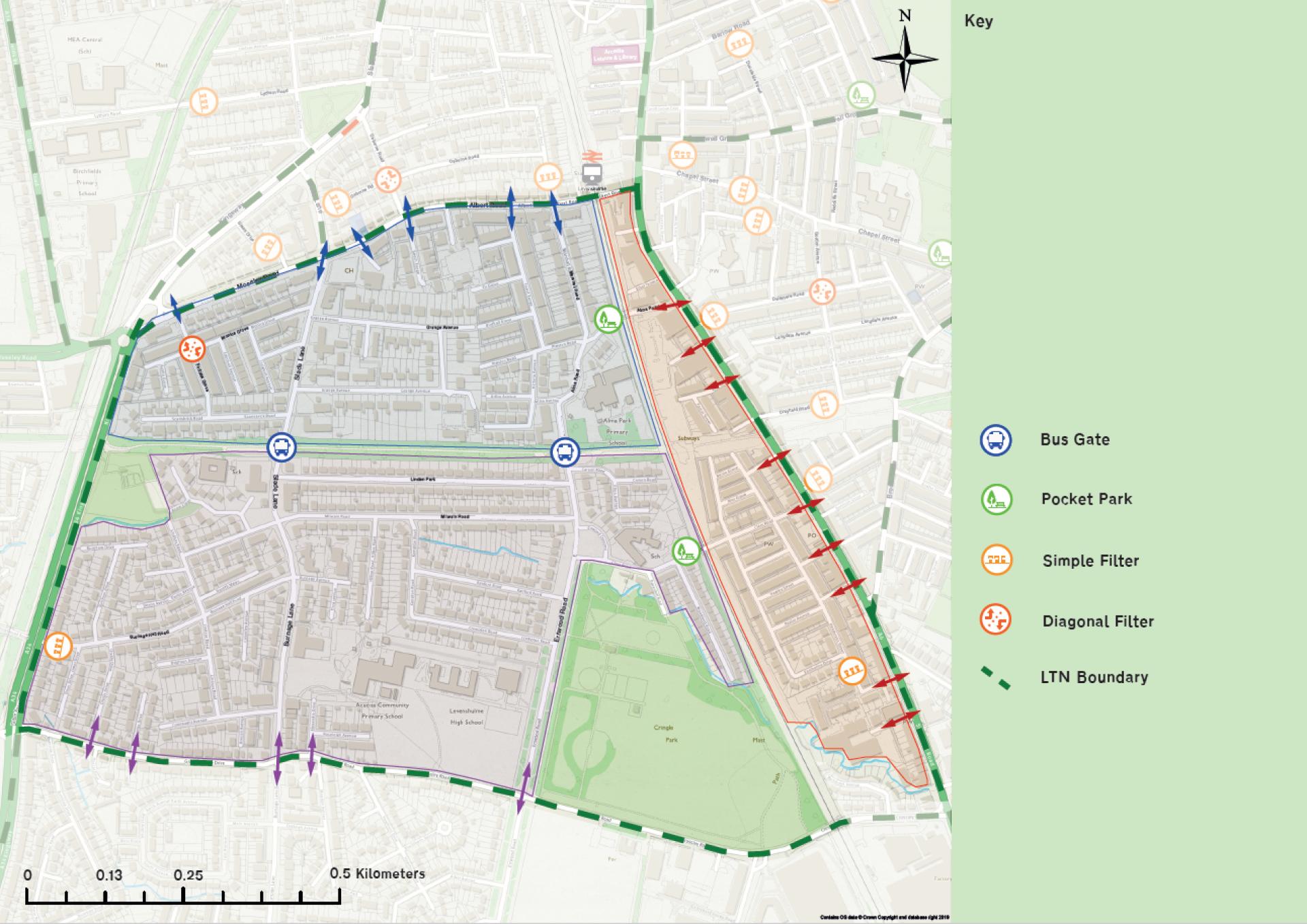
Figure 3f: LTN proposals and vehicle access routes.